Md Ashraf
Geophysicist
I am an aspiring geophysicist with a strong foundation in applied geophysics, geospatial analysis, and seismic studies. Currently pursuing a Master’s in Applied Geophysics at IIT (ISM), Dhanbad, I am passionate about understanding Earth's dynamic processes through advanced data analysis and innovative research methodologies. With hands-on experience in GPS data processing, petrophysical analysis, and industrial automation, I aim to contribute to geophysical research, focusing on seismic hazards, earth deformation, and climate change impacts. I thrive in collaborative environments, constantly seeking opportunities to learn and grow both professionally and academically.
- From: Bihar, India
- Lives In: Dhanbad, Jharkhand
- Age: 23
- Gender: Male
My Skills
Technical skills
Python
MATLAB
GAMIT/GLOBK + GMT (GENERIC MAPPING TOOLS)
Seismic-Unix + Tesseral
MS-WORD, MS-Power Point, Ms Excel
Soft Skills
Communication
Leadership
Time management
Problem Solving
Adaptibility
Education
-
2023-2026
Msc Tech (Applied-Geophysics)
IIT (ISM) DhanbdGPA: 8.07/10.00
-
2019-2022
B.Sc Physics (Hons)
Patna Science College, Patna UniversityScore: 74.38%
-
2019
Intermediate
+2 Islamia High School, Simri BakhtiyarpurScore: 84.8% (2019)
-
2017
Matriculation
+2 Islamia High School, Simri BakhtiyarpurScore: 86.6 %
Experience
-
December 2024
GeoPhysical Field Training
IIT (ISM) Dhanbad -
June 2024
Training on Glacier Studies and Remote Sensing
Divecha Centre for Climate Change, IISc BangaloreFocused on glaciology, including glacier and snow cover distribution, remote sensing, and climate change impacts. Experienced in performing topographic reflectance corrections, estimating glacier depth, and evaluating climate-related impacts
-
December 2023
Geological Field Training
Indian Institute of Technology(ISM),DhanbadMap orientation,Front and Back bearing, Analysis of rock types and mineralogy, Assessment of rock strength with related tests, and measurement of dip and strike of geological structures.
Projects
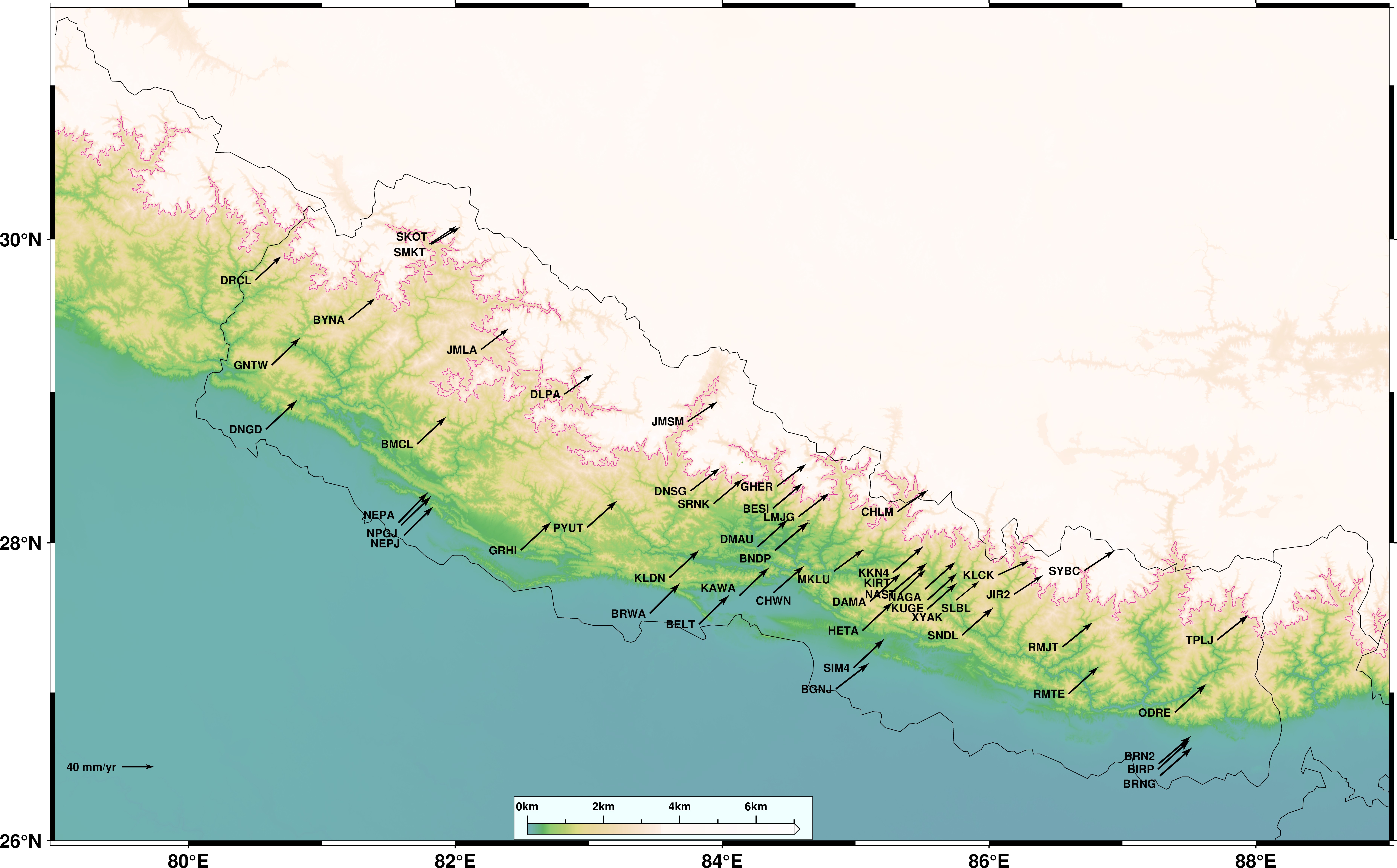
To Estimate the Co-seismic Surface Deformation using GPS Measurements
IISc Bangalore
Date: May 2024 - July 2024
- Investigated the 2015 Gorkha earthquake’s impact on crustal deformation and GPS sites velocities using GAMIT/GLOBK.
- Processed GPS data from 26 GNSS and 12 IGS stations over the period of 2010-2016.
- Generated earthquake movement-related time-series plots and evaluated earthquake-induced surface movements and deformation.
- Converted CNX format data to RNX and performed data processing to ensure accuracy and completeness in the analysis.
Petrophysical Case Study of Gorgonichthys-1 Well – IIT (ISM) Dhanbad
IIT (ISM) Dhanbad
Date: March 2024 - April 2024
- Conducted a comprehensive petrophysical case study of the Gorgonichthys-1 well, including sonic tool design, wireline log quality control, outlier detection, porosity estimation, velocity analysis, shale volume, and water saturation estimation, and advanced reservoir characterization.
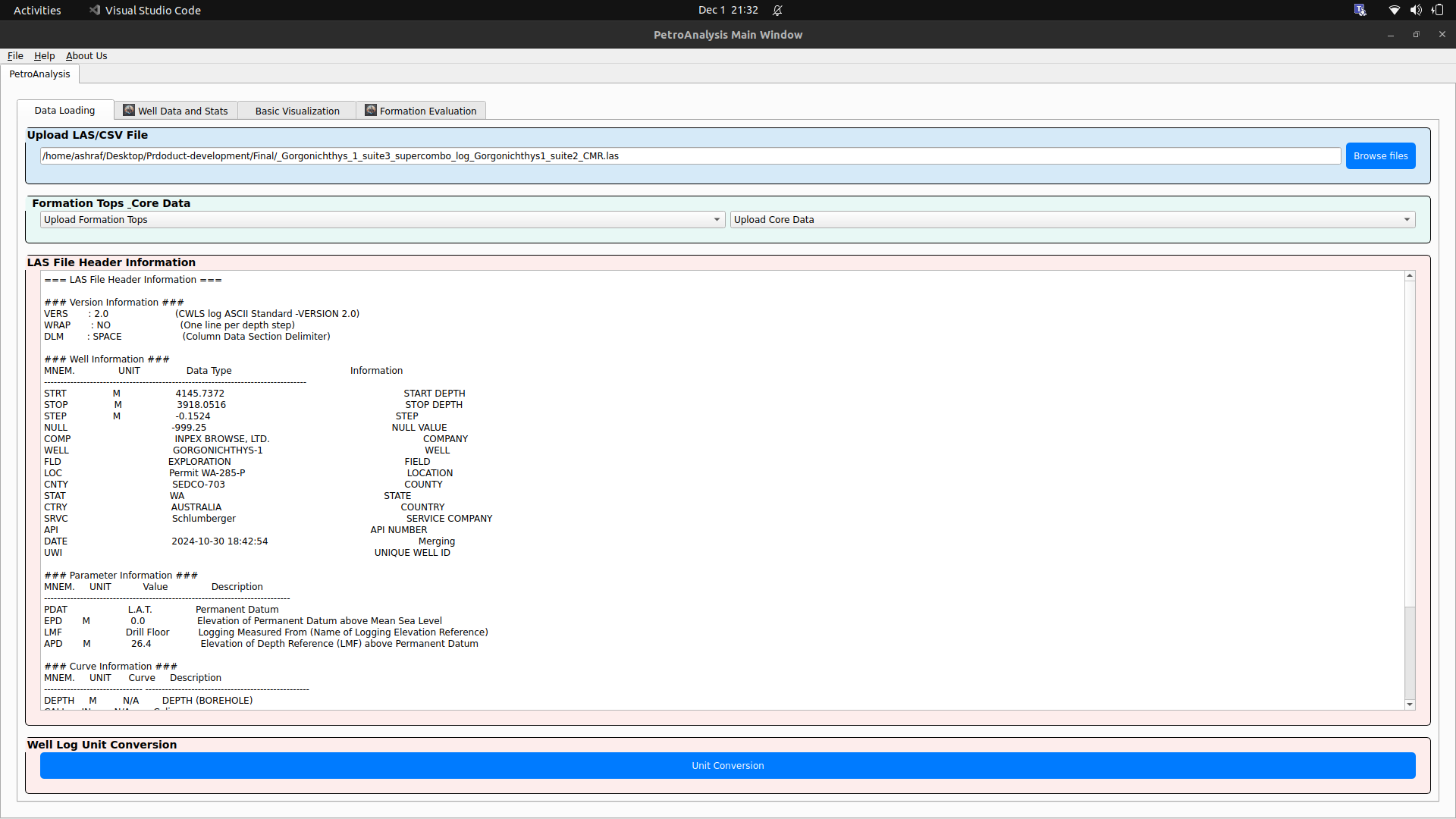
Desktop Application - GUI of Basic Petrophysics Code
IIT (ISM) Dhanbad
Date: August 2024 - November 2024
Objective: To create a desktop application with a user-friendly interface that allows users to input, process, and visualize basic petrophysical data.
Features:
- User Interface: Simple data input forms for petrophysical parameters (e.g., porosity, permeability, water saturation). Interactive data visualization (Multitrack, histograms, cross-plots) for petrophysical results. Data import/export capabilities (support for common file types like LAS, CSV, XLXS).
- Core Functionality: Basic petrophysical properties calculations (e.g., Archie’s equation, shale volume, effective porosity). Parameter sensitivity analysis (graphical sliders for parameter variation).
- Visualization: Plotting petrophysical logs with depth (track-based visualization). Cross-plots between porosity, resistivity, and other derived parameters.
Technology Stack:
- GUI: PyQt, Tkinter (for standalone applications).
- Backend: Python-based petrophysical calculations modules and Visualization modules.
Service
Positions of Responsibility
EAGE IIT ISM Student Chapter
Content Writer
SEG Student Chapter
Content Writer

Chegg (EdTech)
Subject Matter Expert